It is no longer feasible to indefinitely protect the health, safety, and welfare of growing populations while consuming their source of life. This does not mean that protection is irrelevant. It means that we are now aware that this is no longer a world without end, that annexation cannot be pursued indefinitely, and that planning policy must be revised to reflect this awareness.
Adequate shelter has always been a component of the ambiguous term “welfare”. It also affects our health and safety. In fact, it affects our physical, social, psychological, environmental, and economic quality of life. We cannot survive without it, and we cannot survive when it is allowed to sprawl without limit across the face of the planet like an oil spill.
It has now become apparent that we must shelter growing populations within a geographically limited, symbiotic Built Domain that protects their health, safety, quality, and source of life – The Natural Domain. Unfortunately, we have an inadequate vocabulary and leadership language to pursue the goal. The underlying premise of the goal is that master plans and zoning regulations were successful in separating incompatible, unsafe, and unhealthy land use activities; but have been unsuccessful in guiding annexation and the formation of shelter toward geographically limited, economically stable, and self-sufficient cities that protect a population’s quality and source of life.
I’d like to begin with an analogy that explains what I mean when I use the words power, policy, goal, strategy, objective, tactic, information, intelligence, and execution.
INTRODUCTION
Franklin Roosevelt struggled with public opinion and a congressional policy of political isolation for years. Opinion and policy were reversed when the Japanese invaded Pearl Harbor and Germany declared war. Roosevelt now had the power to respond with a declaration of war, and Congress abandoned its policy of isolation. George Marshall was given the responsibility for victory. It was a goal that included the planning and correlation of national effort. Eisenhower was given the responsibility for strategic success through correlation of planning and command from England. Field commanders were given the responsibility for correlation of armies and divisions in pursuit of plan objectives. The officer corps was given the responsibility for correlation of tactical effort to achieve an objective in the plan. Non-commissioned officers were given the responsibility for correlation of execution by individual heroes attacking or defending an objective.
The word “correlation” appears throughout the previous paragraph, and it is teamwork by another name. What isn’t mentioned is “intelligence”. It begins with imagination that raises a question. Information is required to distill an answer. Distillation reduces information to knowledge and options. Options are reduced to decisions. Decisions are correlated to produce direction. Failure to ask the right question leads to inadequate information, arbitrary evaluation, unstable decisions and uncertain leadership direction.
INFORMATION
The right question depends on an adequate vocabulary. It has been building since we began to name the drawings and parts of predator and prey in the caves of Lascaux, Font-de-Gaumme, Altamira et al. Accumulation of vocabulary eventually enabled the construction of a parallel road as science began to define the objects, anatomy, and function of all plants and animals in the Natural Domain. We now live in a Built Domain with another inadequate vocabulary. It restricts our ability to form questions and explore shelter options that do not threaten our source of life.
MEASUREMENT, EVALUATION and PREDICTION
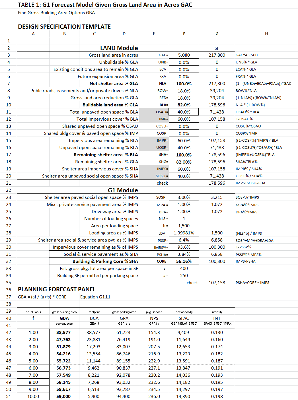
A forecast model predicts the capacity of land to provide shelter within a limited geographic area based on the values entered in its design specification template. The model presented as Table 1 pertains to the G1 building design category. It applies to buildings served by surface parking around, but not under, the building; and contains a Land specification module and a G1 specification module. There are fifteen boxes that request value decisions in the two modules. Thirteen of these values are correlated by an algorithm to calculate the core area available for building and parking cover in cell G32. The master equation in cell A37 requires additional value entries in cells F33 and F34. When all values are entered, the equation predicts gross building area options in cells B42-B51 based on the ten floor quantity options entered in cells A42 to A51. The options change when one or more values are modified in the specification.
The language of City Design begins with the recognition that (1) There are now two worlds on a single planet -- The Built Domain and The Natural Domain; (2) There are four divisions within The Built Domain – Shelter, Movement, Open Space, and Life Support; (3) There are six primary building design categories within the Shelter Division; (4) A design specification template and master equation can predict shelter capacity and intensity options for each building design category; (5) A change in the values entered in a design specification produces a shelter capacity option for comparison and evaluation; and (6) Many specification values are undesirable.
Further explanation of Table 1 can be found in “The Density Distraction”, and “Removing the Blindfold from Economic Development” on my website and in my book, The Science of City Design.
The values entered in Table 1 were anecdotal. We need measurement and evaluation to improve value decisions for each specification item in Table 1, and in all tables that are part of the language of city design.
POLICY
The specification values entered in Table 1 were correlated by the algorithm in Col. H and the master equation in cell A37. Comparison and evaluation of the results produced in cells A42-A51 with measurements of existing specifications and conditions can begin to define a value spectrum for city design decisions that is capable of protecting our quality of life without consuming our source of life. This is the vocabulary we need to define shelter strategy in a leadership language capable of contributing to a policy that I’ll call symbiotic survival.
THE POWER to PLAN
A second form of correlation involves relational databases. When two fields of information are identical in two separate databases, all information in both databases can be shared to reveal previously unrecognized relationships. The problem is that separate database owners are reluctant to share under any privacy protocol agreement. There is also fear of the relationships that may be discovered, since they could have real estate value implications. The result can be avoidance, denial, and deceptive opinion that inevitably lead to decline. These are problems that plague city planning and design efforts. Public opinion and special interest advocacy become substitutes for knowledge. Sharing information reduces the power of the repository. The result is opinion filling a void in knowledge, and isolated information that cannot support a strategy to achieve economic stability and symbiotic survival.
City planning does not have the legislative power to insist on sharing agreements, and rarely has the budget to implement them; because it has not justified the request with an adequate information plan and explanation of public benefit. Credibility will improve with proof that it is possible to accurately predict gross building area options for the six primary shelter design categories on the planet. Table 1 was presented as an example of the proof provided in The Science of City Design. The gross building area options presented in cells B42-B51 are examples of the power to calculate shelter capacity potential and intensity implications for a given land area under specified conditions. This information is useful in its own right, but becomes powerful when gross building area measurements and forecasts are linked to their many implications. Unfortunately, these implications can only be discovered when information in separate databases is connected. For instance, real estate tax, income tax, and population data is contained in three separate databases. Condition and location ratings are rarely collected on a consistent schedule in any database.
The objective is to predict gross building area options per acre of buildable land available. This is called shelter capacity and is occupied by activity. The acre allocations for activity have been called zones. Zones, census blocks and tracts contain shelter capacity that produces average revenue per acre. This revenue offsets the average public expense per acre to deliver a desired quality of life; but revenue can be inadequate to meet an objective since all acres do not produce the same yield. When added together and combined with all other available revenue, however; they must produce an average yield per acre equal to a city’s average expense per acre.
The goal is to measure current yield and predict future acres of activity allocation that can improve a city’s average revenue per acre. The objective is to improve a city’s quality of life without excessive intensity. The balancing act is called “city design”, and it will depend on the creation of a relational database network. It is needed to link a city’s shelter capacity, intensity, and activity plan to its social, psychological, environmental, ecologic, and economic implications. There is no option. We either learn to perform the balancing act required or continue to consume our source of life.
A few isolated databases related to city design immediately to mind. They involve (1) Real estate, (2) Income tax and other revenue, (3) Zoning districts including land use activity and physical condition, (4) Census, and (5) Traffic. (Each zoning district would have to be numbered since the same district can be present in different geographic locations.) Each database includes extensive lists of information, and they all contain a few common fields. These common fields can be assembled to form an address database. It can be used to link all separate information under an accepted privacy protocol. For example, a database that lists a street address and its related parcel number(s), census block, census tract, and zoning district designations can be used to correlate all information compiled by any of these primary keys. This makes it possible to plan for urban form that represents far more than physical appearance.
A relational database represents connected information waiting for an idea. For instance, it can be used to link activity and capacity options for a given land area to its real estate tax implications. When shelter capacity options can be forecast in gross building area per acre, the results can be multiplied by the real estate tax potential per square foot of occupant activity to calculate potential revenue yield per acre of shelter capacity and activity.
Real estate tax potential per acre of land and square foot of building activity is intelligence that can be distilled from a real estate database and correlated with land use information in a planning database. The result is revenue per square foot of activity. It can be multiplied by predicted shelter capacity options in square feet per acre to reveal future strategic alternatives for economic improvement. Future percentages of land use activity and shelter capacity allocation can then be evaluated on a more rational foundation. The underlying message is that a city is a farm, the land is its resource; and the way it uses this land determines the yield available to serve shelter populations and deliver quality of life that protects its source of life.
The same relational database concept can be used to link land use allocation and shelter capacity per acre options to their income tax implications. When shelter capacity options can be forecast in gross building area per acre, the square foot options can be multiplied by the income tax potential per square foot of occupant activity to derive the potential revenue yield per acre. The potential yield per acre can be multiplied by the acres of activity contemplated to predict the role this percentage of land use allocation would play in meeting a city’s average expense per acre. However, a privacy protocol would have to be established to protect individual information.
Aggregations of income tax data by census block, tract, activity or zone will make it possible to evaluate the economic potential of future shelter capacity and activity allocation when database cooperation is accepted. Informed city design decisions cannot be pursued until: (1) A city understands the shelter capacity, intensity, intrusion, and dominance options available, (2) Is capable of evaluating the implications of shelter capacity and occupant activity options, and (3) Can balance the revenue potential of shelter capacity and activity options to protect its physical, social, psychological, environmental, ecologic, and economic quality of life within a limited Built Domain.
CONCLUSION
IF you believe (1) That strategic plans are needed to protect a city’s health, safety, and welfare within a symbiotic Built Domain that is limited to protect its source of life, and (2) That information must precede the formation of strategic options and the adoption of strategic plans; THEN you recognize that public opinion based on emotion, special interest logic, and wishful thinking is a weak substitute. Improved knowledge is required, but it requires better tools and better homework. The tool involves accurate shelter capacity, intensity, intrusion, and dominance prediction that I’ve referred to as the vocabulary and language of City Design. The homework involves the creation of an address database; the organization of a relational database; the measurement and evaluation of existing physical conditions; and the imagination to seek the right answers from the data correlation enabled.
A policy represents approval to pursue a goal. I suggested that a policy of symbiotic survival be adopted. One objective is to lead shelter for growing populations toward a geographically limited, symbiotic Built Domain that protects their health, safety, quality, and source of life – The Natural Domain.
A declaration of policy intent regarding our presence on the planet has not been considered. A goal has not been defined, and objectives have not been listed. The closest we’ve come is climate change, which could be solved while we continue to consume our source of life. The lack of intent and definition of a goal means that a strategic plan is missing and the intelligence required has not been pursued or correlated. If we wait to reverse our own indifference, we can easily lose before we agree on the threat; and it will not be as obvious as a raid on Pearl Harbor or a declaration of war from Germany. Recognizing a threat has required instinct, intuition, and awareness that have always stimulated imagination; but we have had proof of a threat to stimulate a response. In this case, imagination must substitute for proof to give us time to respond. This substitution represents the next level of adaptation.
------------------------------
Walter Hosack
DublinOH
------------------------------